Johann Heinrich von Thünen, a German economist and farmer, introduced this model in 1826 in his book Der Isolierte Staat. It’s one of the earliest attempts to explain rural land-use patterns using economic principles.
Origin of the Model: In 1826, Johann Heinrich Von Thünen introduced a theoretical model of agricultural land use in his book Der Isolierte Staat (The Isolated State).

Who Was Von Thünen? He was a German economist and farmer, influenced by Adam Smith. He spent 40 years farming in Mecklenburg, Germany, where he gathered practical data to support his theory.
Basis of the Model: The model is based on real-life observations from Mecklenburg, a region with low-fertility sod-podzolic soils. Von Thünen used his farming experience to develop a structured explanation of how land is used around a central market.
Purpose of the Model: Von Thünen aimed to show how and why different types of farming occur at different distances from a market town. His model helps explain the relationship between:
Table of Contents
ToggleThe model is built on the concept of economic rent—the idea that farmers choose crops and land based on how much profit they can make after covering land and transport costs.
Von Thünen’s model explores how agricultural activities are spatially organized around a central market city. The key idea: land use is determined by transportation costs and land rent, with farmers aiming to maximize profits.
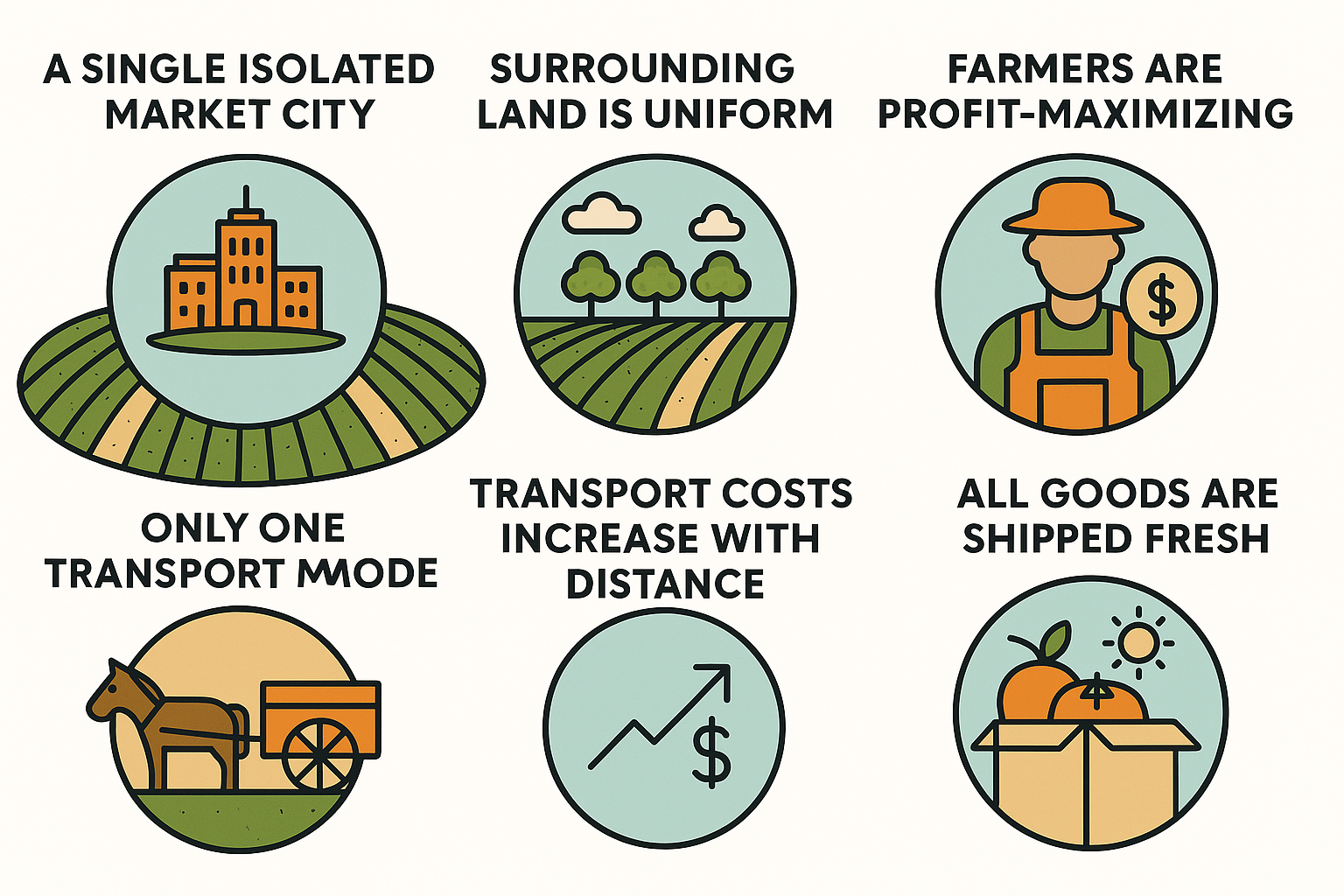
Johann Heinrich Von Thünen built his agricultural land use model on a set of ideal conditions to explain how farming patterns change with distance from a central market.
why farmers grow different things at different distances from a city.
1. Intensity of Production Declines with Distance The farther a farm is from the market, the less intensive its agriculture becomes. Intensity refers to how much input (money, labor, fertilizers) is used per unit of land. Closer farms use more inputs to grow high-value or perishable crops.
2. Type of Land Use Varies with Distance Different crops and farming methods are chosen based on how far the land is from the market. Perishable and high-value crops are grown near the city, while extensive farming like livestock or grain happens farther away.
| No. | Assumption | Explanation |
|---|---|---|
| 1 | Isolated State (Model Economy of Thunen) | The model assumes a single market city surrounded by its agricultural hinterland, with no outside trade. |
| 2 | Single Market | The city is the only buyer of surplus farm products; no other cities are involved. |
| 3 | Exclusive Supply | Farmers sell only to this city and not to any other market. |
| 4 | Uniform Environment | The land around the city is flat and has the same soil and climate conditions. |
| 5 | Profit-Seeking Farmers | Farmers aim to maximize profits and adjust their crops based on market demand. |
| 6 | Single Transport Mode | Only horse and wagon are used for transportation (as it was in 1826). |
| 7 | Transport Costs Increase with Distance | Farmers pay all transport costs, which rise with distance. All goods are shipped fresh, so perishability matters. |
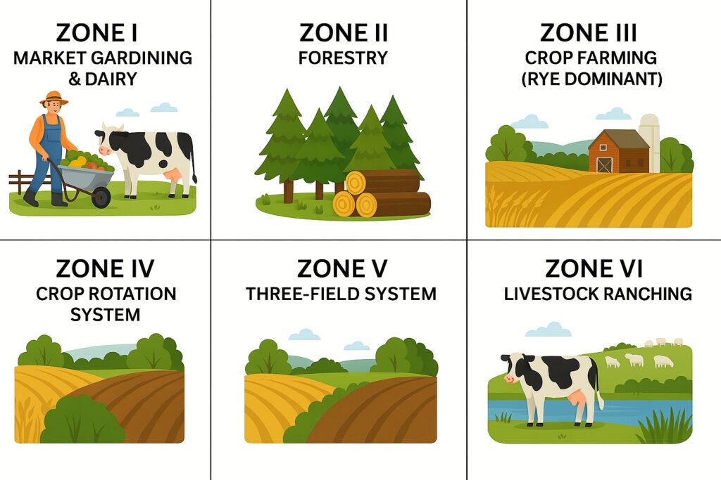
Building upon his foundational assumptions, Johann Heinrich von Thünen developed a model of agricultural land use that consists of six concentric zones surrounding a centralized market town. Each zone represents a distinct type of agricultural activity, spatially arranged according to economic efficiency.
The model was designed to analyze how production choices are influenced by the cost of transportation, market prices, and land rent, ultimately guiding farmers in optimizing land utilization based on profitability.
Von Thünen introduced the following formula to determine the economic rent (R) per unit of land:
The formula illustrates how profitability decreases as transportation costs rise with distance, influencing land use decisions around a central market.
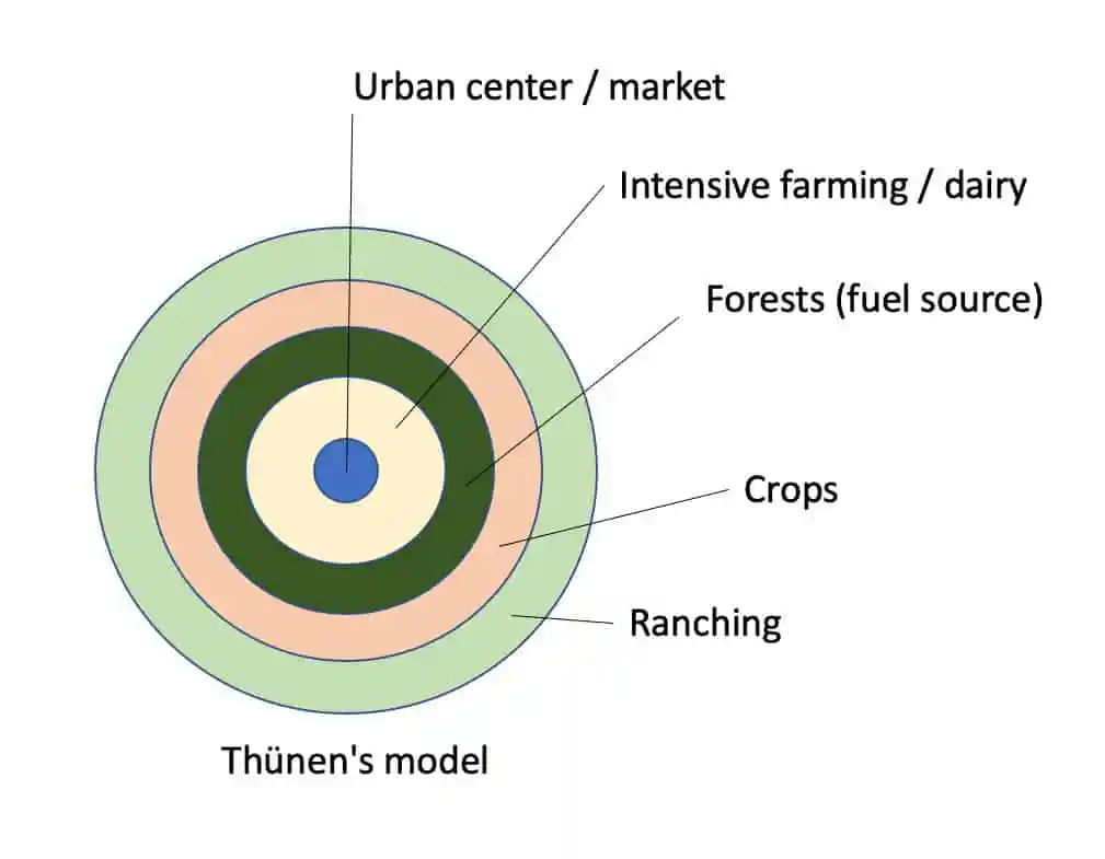
Von Thünen imagined a central urban market (often called the Central Business District or Downtown) surrounded by rings of farmland. Each ring represents a different type of agriculture, chosen based on how far it is from the city and how much profit it can generate after transport costs.
The heart of the model.
All agricultural goods are sold here.
Farmers aim to maximize profits by choosing crops that balance production cost and transport expense.
Closest to the city.
Produces fresh milk, vegetables, and other perishable goods.
High land fertility maintained through manuring, often using waste from the city.
Known as truck farming in Europe.
High transport cost perishable goods require proximity to market.
Produces wood and fuel, which are bulky and expensive to transport.
Despite lower land fertility, forestry earns high locational rent due to high transport costs.
Wood was in great demand in the 19th century for heating and construction.
Focuses on grain crops, especially rye.
No crop rotation or manuring—soil fertility gradually declines.
As distance increases, intensity of cultivation decreases, leading to lower yields.
Moderate transport costs allow for less perishable goods.
Uses a seven-year rotation:
1 year rye
1 year barley
1 year oats
3 years pasture
1 year fallow
Products include rye, butter, cheese, and live animals.
These goods are less perishable, so they can be produced farther from the city.
This zone uses the traditional three-field rotation method:
One-third of the land is used for field crops (like rye or barley).
One-third is kept as pasture.
One-third is left fallow to restore soil fertility.
The crops and products here are less perishable, such as butter, cheese, and live animals, which can be transported over longer distances.
Due to the distance from the market, transport costs are higher, and land rent is lower.
This is the outermost zone, farthest from the city.
Focuses on animal husbandry—raising cattle, sheep, and other livestock.
Rye and grains grown here are mainly for local farm use, not for sale.
Products like meat, cheese, and hides are sent to the market, as they are non-perishable and can withstand long transport.
This zone has the lowest land rent and least intensive farming.
While Von Thünen’s model provided a foundational approach to understanding rural land-use planning, several scholars and practitioners have pointed out notable limitations:
The model is based on the notion of a geographically isolated state, with a single central market surrounded by uniform land.
In reality, such conditions are rare or non-existent—markets are often interconnected, land varies in fertility, and geographic barriers like rivers and mountains distort concentric patterns.
As a result, the regular zonal rings proposed in the model are difficult to observe on actual landscapes.
Von Thünen assumed that farmers are driven by profit and will always aim to maximize economic rent.
This may hold true in capitalist economies, but during feudal times, farmers often prioritized subsistence over surplus.
Once basic needs—such as food and provisions for winter—were met, production ceased regardless of profit potential.
The concept overlooks non-economic motivations in traditional societies.
The model is purely economic and does not account for traditional rural cultures, social values, or customary land-use practices.
Decisions in agricultural communities are influenced by heritage, rituals, kinship ties, and non-commercial goals.
By omitting these factors, the model fails to capture the full complexity of rural land-use behavior.
Olof Jonasson, a Swedish geographer, reinterpreted Von Thünen’s land use theory in 1925 to better reflect the real-world agricultural patterns of Europe and North America. His key contribution was to relate economic rent not only to market distance but also to transportation infrastructure and industrial centers.
Industrial Centers as Focal Points Unlike Von Thünen’s isolated central market, Jonasson observed that agricultural zones were arranged around industrial hubs, which acted as both production and consumption centers.
Hay and Pasture Dominance In both Europe and North America, the most intensive agricultural activity—hay and pasture farming—was found closest to industrial centers, supporting urban livestock and dairy needs.
Concentric Land Use Patterns Surrounding these pasture zones, Jonasson noted concentric rings of:
Grain cultivation
Extensive pasturing
Forestry
Transportation Influence Jonasson emphasized the role of transport routes (railways, roads, rivers) in shaping land use, challenging Von Thünen’s assumption of uniform transport cost across space.

In 1952, geographer Samuel van Valkenburg adopted Olof Jonasson’s modified version of Von Thünen’s model to analyze agricultural intensity across Europe. His work provided a practical application of theoretical land-use models on a continental scale.
Agricultural Intensity Mapping Valkenburg created a map showing land productivity per acre across Europe, based on eight major crops:
Wheat, rye, barley, oats, corn, potatoes, sugar beet, and hay
Index-Based Yield Comparison
The average yield per acre for Europe was set as an index of 100
Each country’s specific yield was then compared against this benchmark
Countries like Netherlands and Belgium led in agricultural intensity, followed closely by Denmark, Switzerland, and England
Factors Behind High Productivity
Extensive use of fertilizers
Careful crop rotation
Strategic seed selection
Continental Application of Von Thünen’s Model Valkenburg’s findings showed that Von Thünen’s concentric land-use theory could be applied to major European agricultural markets, especially:
Northeast France
The Netherlands
Belgium
Southeast England
North Germany
Denmark

Von Thünen’s model is a theoretical framework explaining how agricultural land is used around a central urban market. It organizes farming activities into concentric zones based on transport cost, perishability, and economic rent.
Zone I: Market Gardening & Dairy
Zone II: Forestry
Zone III: Intensive Grain Farming
Zone IV: Mixed Crop Rotation
Zone V: Three-Field System
Zone VI: Livestock Ranching
The model is based on an isolated state with one central market.
Uniform transport cost per distance unit.
Farmers aim to maximize profits.
Land is flat and equally fertile.
It assumes a simplified and unrealistic geography.
Ignores cultural and subsistence factors in traditional farming.
Assumes profit-driven behavior, which wasn't applicable during feudal times.
Fails to account for modern transport infrastructure and multiple markets.
Jonasson related economic rent to transportation and industrial centers, not just distance from a central city.
He observed actual land-use patterns across Europe and North America.
Agricultural zones were arranged around industrial hubs, with hay and pasture farming closest to them.
Valkenburg applied Jonasson’s approach to map agricultural intensity in Europe.
Used eight major crops to create a land productivity index.
Found that areas like Netherlands, Belgium, Denmark, and England had the highest intensity due to fertilizers, crop rotation, and seed selection.
His work validated Von Thünen’s theory at a continental scale.
You are stronger than you think.